
The Best Guide Book, Maps, and Navigation Apps for the John Muir Trail
Here's our recommendation for a good guide book, maps, and navigation apps for your John Muir Trail thru-hike, with a funny introduction we call "the cover guy story".
This article is part of our series: Along the John Muir Trail in 18 Days.
The Cover Guy Story
It was day 6, and we were towards the end of one of the most difficult legs of our trip. Earlier, Timea had a hip issue and we had to scramble to make her pack lighter so she can continue hiking. She was fine eventually but, because of that injury, we both got very tired on the steep ascent to Silver Pass. The hot mid-afternoon sun did not help either.
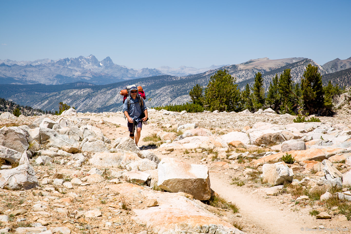
We were so happy when we reached the pass. I took my pack off and went looking for a photo opportunity when I saw a backpacker hiking towards me (photo above). I looked at him and said to myself: "wow, there is something iconic about this hiker, I've got to take a picture of him with those rugged picks in the background" - the tallest is Banner Peak. The frame I had in my mind was just too good to pass, so I went ahead and composed it, then clicked the shutter.
When the hiker approached more, I asked if he was ok with me taking his photo - he was. I told him he looks very familir. I was sure I'd seen him somewhere else before.
Then came his surprising response, while wearing a big smile on his face:
Of course I look familiar, I'm the guy on the cover of the book!
I was speechless for a second. Yes, I remembered him on the spot. He was, indeed, the guy on the cover of the John Muir Trail guide book by Elizabeth Wenk. Who would have thought we'd meet such a trail celebrity on our first JMT hike?!
The Guide Book
Right after we decided we were going to try to hike it, we purchased Elizabeth Wenk's John Muir Trail book, mostly based on the good reviews on Amazon. The book is well structured and contains a lot of useful information.
The Planning Section: The most important is the planning section, which is invaluable in preparing for the trip, learning about the trail, about permits, supplies, transportation, logistics, weather, and so on. We ended up reading parts of this section more than once. I'm sure the same can be gathered online, but why bother and risk missing something when you have everything in one place, so nicely laid out for you.
On-the-Trail Section: The book continues with a section on the history of the Sierra and a section-by-section guide. We chose to read those later while on the trail. We struggled whether to take the physical book with us in its entirety or break it down by sections and ship it in our re-supply boxes. Eventually, we decided to do neither and purchased the Kindle version, which weighs nothing. It turned out to be a great idea because we ended up reading a lot on the trail, especially while resting in our tent. We learned these little insights about the area that helped enrich our overall experience.
This guide book helped us a lot, both in planning the trip and on the trail. We recomend it.

Invaluable for trip planning: trailheads, permits, supplies, gear, logistics, camps, water, weather, and so on.
Great to have on the trail because of the insights it provides about the area.
The Kindle version weighs nothing.
If you won't have a phone with you, break it down into sections and ship them with your resupply.
Maps
They're essential for navigation, but also for planning, especially on such a long trip where you want to at least get an idea about the terrain before getting there in person.
There are several options for maps of the John Muir Trail. Two of the most popular are:
The Tom Harrison Maps: has very good reviews, but we chose not to purchase this product because it contains individual/loose pages for each day/couple of days. While you may think that's a good thing, as you want to keep only the most recent section with you or out of your pack, I'm glad we did not choose this product for our trek. Read on to find out why.
The National Geographic Map (booklet): like the Harrison maps, the National Geographic maps also have outstanding reviews. We chose this set because they're bundled in a booklet, and boy I'm glad we did. Besides checking our current position, there were many times when we wanted to go back and check out an area that we passed through several days before, or go ahead of our current position and examine what's next for several days. We also used the booklet to go back and count passes, lakes, and other stuff that we found interesting on the map. The maps are narrow enough to carry in your side-pocket and taking the booklet out for a quick check is a matter of seconds. All these activities would have been a mess if we had to deal with individual pages.
Our recommendation goes with the National Geographic John Muir Trail Map:
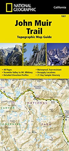
A must have on the trail.
Great for planning, too.
Distance covered/remaining.
Elevation profile.
Segment length.
Accurate camps and water sources.
A sample day-by-day schedule with camps and mileage.
The booklet is great to browse during breaks to check progress and count stats, like passes lakes, miles, etc.
Navigation Apps
While not absolutely necessary, having a navigation app on your phone to complement (not replace) your paper maps is very useful. If nothing else, you can at least see where you are so you can reference that point on the main map and make decisions about camps, water, breaks, etc. If you're planning on carrying your phone with you, it's worth the extra few bucks and effort in getting a navigation app on your device.
Both Timea and I carried our phones on the John Muir Trail, with a solar panel to recharge. We both had the map apps on our phones (shared though iOS Family Purchases).
These are the navigation apps we used and recommend, each with their own advantages. Here's what we liked best about each:
Guthook JMT Guide has a set of nice features we liked:
Trail and elevation profile.
Waypoints, water sources, camps, points of interest, services.
Distance to next water source, or camp.
List of stuff ahead, with an easy way to navigate forward/backward.
Images of camps and other waypoints.
Ability to turn GPS on/off, quick signal acquisition.

Gaia GPS Classic is the version we used. They released a new version now, subscription based, called Gaia GPS: Topo Maps and Hiking Trails. You can't go wrong with either of these versions. They're not specific to the John Muir Trail like Guthook's JMT Hiker is, but as far as features, the sky is the limit.
Once you purchase the app (or service), maps are free.
Tracking and recording.
Trip stats.
Works in airplane mode.
Lots of other features.
Download on the App Store: Gaia GPS Classic | Gaia GPS (new version)
Happy Hiking
Well, I hope these details inform you in making a good decision for your trip.
Oh, and do take a camera with you, because, if you see an iconic hiker heading towards you, it might be the guy on the cover of the book.
Good luck meeting your John Muir Trail celebrity and have the time of your life on the trail.
This article is part of our series: Along the John Muir Trail in 18 Days.