
Backpacking Navaho Pass and Navaho Peak, a Weekend Trip

Navaho Pass and Navaho Peak are one of the best choices for early season backpacking, with lots of options for extending your trip or exploring around camp.
13 miles roundtrip, 3000' gain with a high point of 7223', Green Trails Map: Mount Stuart No 209, trailhead@ 47.3665, -120.8025 - WTA
Navaho Pass Day By Day
Day 1: Hike 5 miles to camp, hike 2 more miles roundtrip to reach Navaho Pass and summit Navaho Peak
Day 2: Scramble around the pass
Day 3: Hike 5 miles back to Stafford Creek trailhead
Scroll down for a recount of our trip and lots of photos.

The hike follows Stafford Creek through a dry forest
Day 1: Stafford Creek Trail
We started the trip at Stafford Creek trailhead. We needed a Northwest Forest Pass to park there, and there was plenty of space this 4th of July weekend.
We hiked the first few miles along the Stafford Creek and through a very dry forest that reminded me of Yosemite, both from seeing the Ponderosa Pines and by its characteristic scent.
The trees offer some cover to keep you cool, but this is definitely a hike to consider bringing a sun hat.

Trail to Navaho Peak is gentle most of the way up
The trail grade was gentle, with short steeper sections every now and then. We did not sweat too much and, before long, we reached the junction with Standup Trail No 1369, 3.8 miles into our trip.
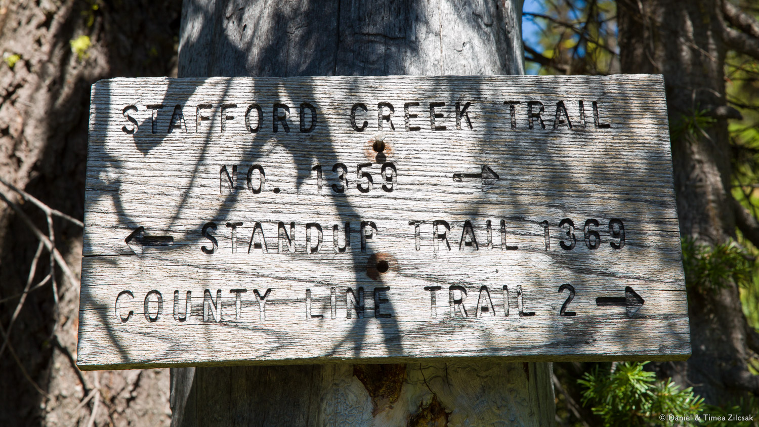
Junction with Standup Creek Trail at 3.8 miles
The rest of the hike to the meadows was very enjoyable, the views opened up even more. We reached our planned camp spot at around 4.5 miles from trailhead, or about a mile from the junction.
Camping at the Navaho Pass meadows
The meadows are 15 minutes below the pass with lots of camp sites to choose from. This area is the greenest place around and a great place to spend the night. Lots of other backpackers set their tents here, but it did not feel crowded at all.
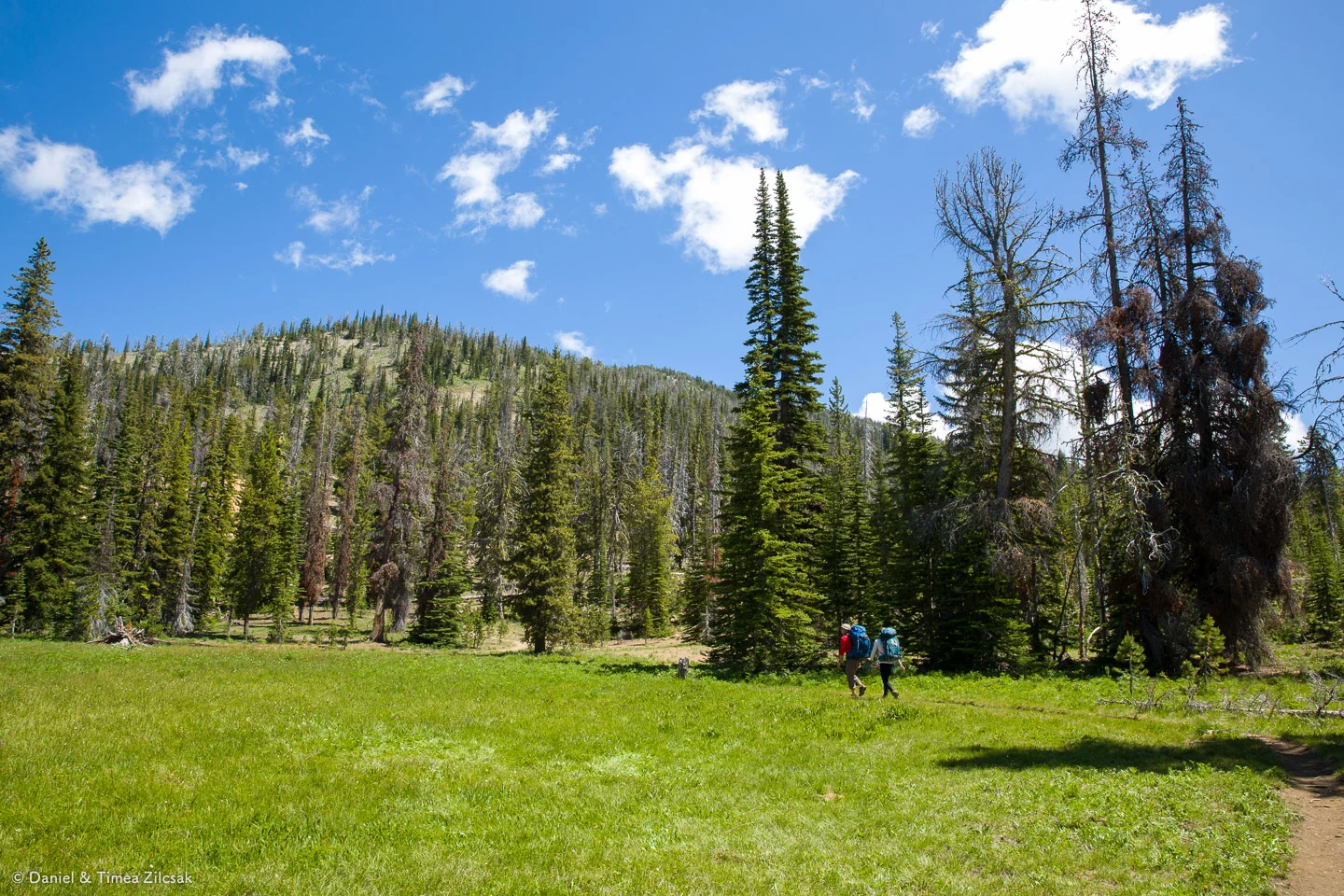
The meadows before Navaho Pass, offering plenty of camp spots for backpackers
Our friends found a great camp spot right around that tall tree in the picture above, but looking closer, we found an even better, more private one, just a few steps deeper. So we set camp there.
Life in camp was made easier by the presence of a nearby creek which was our main source of water.

Filtering water at the Navaho Pass meadows
Navaho Pass
We had plans to hike further after unpacking our tents. From camp, there's a short hike to Navaho Pass, not more than a half mile. On our way there, we passed through a section that somebody called Moon Landing (not sure if that's its name, but it does sound adequate because it's devoid of any plant life).

Moon Landing area right above camp and below Navaho Pass
As I turned around and hiked a few more steps after taking the above photo, I saw the very top of Navaho Pass, with lots of people chatting and looking on the other side. I was so curious to see the view from up there.

Reaching Navaho Pass, anctious to see what's on the other side
And here are the views that we all saw:

View of the Enchantments peaks in the Stuart Range from Navaho Pass, Little Annapurna is straight in the middle

View of the Enchantments peaks in the Stuart Range from Navaho Pass, Little Annapurna is straight in the middle and Mount Stuart is the leftmost peak
The Summit of Navaho Peak
After a few minutes at the pass, we quickly decided that we needed to check out Navaho Peak, an extra 1200' of elevation and 0.8 miles from the pass. The trail was steeper, but in good condition. With every step we could see farther and farther, and the views were unbelievable all around.

Reaching the summit of Navaho Peak

Views west from the summit of Navaho Peak, Mount Stuart is the pointy peak dominating the image

Timea and I on the summit of Navaho Peak, photo by Krisztina Szabo
Something we have not done, but wish we did, was to come back here at sunset. The view to the west must be spectacular on a fiery sunset.
After a full day, we returned to camp and enjoyed dinner, a game of harts, and the usual bourbon hot cider.
Day 2: Scramble around the Navaho Pass
The following day, we had so much time to relax and explore around. We decided to do a hike along the ridge and maybe reach Earl Peak. We did not get all the way to Earl, but the hike itself was spectacular, with grand views of the Stuart Range again, and a little scramble to follow the ridge line along our planned route. All in all, this day will be memorable for everybody in our group. Here are some photos:

Moon Landing area at Navaho Pass, off trail towards Earl Peak

Scrambling off trail to gain the ridge

View of Stuart Range from the county line ridge

On the ridge looking south west towards Earl Peak

Scrambling down to our lunch spot

Looking back towards camp on our way back

Finding our way back to camp and off to get an afternoon nap

Evening view from Navaho Pass
Day 3: Hike Out
We woke up Monday morning enveloped in clouds and cold weather. We had a long breakfast and packed up camp. It was time to hike back.
The weather cleared up eventually, not long into our descent, and, as always, we were already making plans for what's to come.

A flower by the water
Thanks for reading and enjoy your trip!